


Explore Telemark
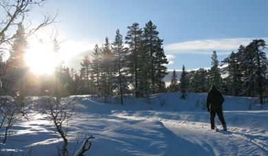
Telemark Mountain


To build your own Itinerary, click  to add an item to your Itinerary basket.
Already saved an Itinerary?


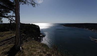
Tangen Fort is located at the far end of Langesundstangen, south of Langesund city centre, and is a popular hiking area. The area is a nature reserve with geological values in the form of fossils and calcareous bedrock.
Stunning vantage point
At the end of Tangen Fort there are benches set up so you can enjoy the breathtaking views of the sea.
This is a great hiking area and the nature here is vulnerable, therefore you should use the roads and the upturned trails. Take care of the place and nature by cleaning up after you. You can feel free to pick berries. In the nature reserve, the same rules apply as elsewhere in the area of fishing, hunting, dog and traffic. It is important to keep the dog on a leash during the period of leashing, which is from 1 April to 20 August.
Cannons and running aisles
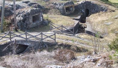
In the 1930s Langesundstangen was used by Langesund's population as a hiking and recreation area. The area was used for walking, social gatherings and dancing. Benches were set up in places with good views. During World War II, the Germans made tunnels, mountain halls, running aisles, bunkers and cannon foundations. The tunnels and bunkers in the mountains are closed today, but many of the structures are clearly visible in the landscape. The Germans also set up a drawbridge and it still stands at the main entrance to the area. Tangen Fort was used by the Navy until 1996, and the area was opened to the public in 1998.
Nature Reserve and Geology
The area is a nature reserve with geological values in the form of fossils and calcareous bedrock.
The unique soil means that many rare species live here, both insects, plants, fungi and lichens. The vegetation at Tangen Fort is characterized by limestone forests with elements of ash-pointed hazel forests, hazel thickets, and patches of lime furu forest. Limestone forest is a habitat where there are many endangered soil-dwelling fungi. A total of 12 red-listed fungal species are registered here, of which 8 endangered. Several red-listed lichens and insects are also found in the area. Read more about the geology in the area.
Parking
Parking at Furustranda: Follow the coastal path to the tip of Tangen Fort. On this trail there are great views to the lighthouse on Langøya.
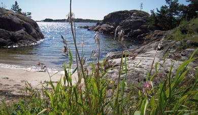
Parking at Steinvika: Follow the coastal path out to Tangen Fort. Steinvika is a protected area and part of Gea Norvegica Unesco Global Geopark
Parking at Skipperhuset in Langesund city centre: Walk across the drawbridge and follow a road out to the tip of Tangen Fort. The road is paved and gravelly. This trail is less hilly than the trails out to Tangen Fort.
Parking at The Town Hall and in Langesund city centre: Follow Tangenveien southwards.
Parking at Krogshavn: Walk the coastal path outwards, via Steinvika. This is a slightly longer route.
Important information
• It is permissible to light a fire and use a grill in an adapted barbecue area. The location of this (at the Commander's Residence) is shown in a new safety map. There is still a ban on bonfire burning and the use of grill elsewhere in the nature reserve.
• It is permissible to cycle on the main road, from the main gate to the surface above the Fort (at WC, about 50 m north of the Fort), as shown in a new safety map. There is still a ban on cycling in other parts of the reserve, both in the terrain and on trails/roads, including down to the fort itself.


The history of Langøytangen lighthouse station dates back to 1828.
The rocks in Steinvika were created in the earth's antiquity, for approx. 461-451 million…
Langesund customs warehouse as it stands today was erected in 1869.
The old guardhouse is now a customs museum, with artefacts found there from long ago.
Tollpakkboden is a log-built warehouse, the main part of which dates from the early 1700s.
Bamble's Landscape - Exciting Geology Through Millions of Years
Great hiking area near Rognstranda in Bamble. Beautiful forests and flora.
Bamble is dominated by two types of landscape with completely different geological…
The landscape with the escarpments, "flauane" in Norwegian, is characteristic of the…
The Olav church ruin (Skeidi church) are the ruins of a stone church built before 1150 in…
At Rugtvedt in Bamble, a new exciting locality has emerged, a sandy beach that was…
As the first geopark in Scandinavia, Gea Norvegica became member of the Global Geoparks…
The Gea Norvegica Geopark visitor center is located at the porcelain factory in Porsgrunn…
 Walking trails in Bamble, Bamble
 Walking tour at Stathelle, BambleBefore Brevik bridge came in 1962, Stathelle was a junction for traffic between the south and east of Norway.
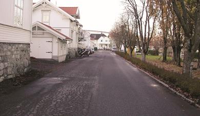
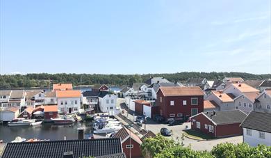 Walking tour in Langesund, BambleLangesund is Grenland’s "white-painted town" by the sea.
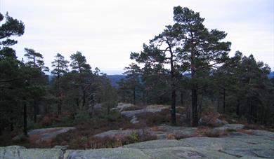
 Rognsåsen, BambleRognsåsen is a popular recreation area in Bamble with a diverse conifer forest.
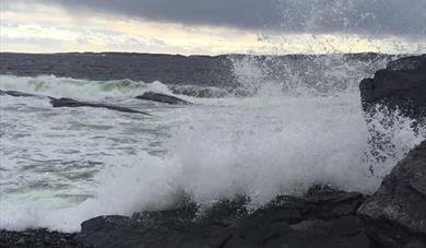 Steinvika in wet and windy weather, Bamble
 Hørsfjell - Bamble highest mountain, Bamble
 Prisgrunn and Ivarsand, BamblePopular hiking area for families with children.
 Trolldalen Kystfort, BambleTrolldalen Kystfort, beautifully located right on the water’s edge in Bamble, was built by the Germans during World War II.
Ratings & Reviews
Powered By
![]()


© Visit Telemark 2026. Copyright
