HIking along the coastal path in Bamble: Åby - Trosby
Type:Coastal trails
3960, Stathelle


To build your own Itinerary, click  to add an item to your Itinerary basket.
Already saved an Itinerary?


This section of the coastal path is relatively easy to walk, and the entire trip is approximately 15.2 km long, with a duration of about 4 hours. It is occasionally a bit steep. The season is all year-round, but spring, summer, and autumn are the main seasons. The difficulty level of the hike is moderate and suitable for adults and children.
Description of the hike
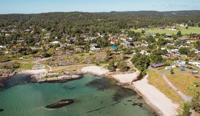
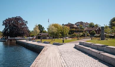
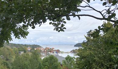
The coastal trail initially follows Valleveien before entering a fairly steep gravel road up to Åstadheia. From Åstadheia to Trosby, you follow trails as well as rocky shores and gravel roads. Exercise caution between Prisgrunn and Ivarsand, as it is a bit steep, but there is a railing to hold onto. Further along the trail, you will reach Vardås (Valås), which offers the best view of Bamble's archipelago, stretching from Langesund in the east to Kragerø in the west. From Vardås, the coastal trail continues to Melby and then to Trosby, where there is a store. From there, you can also walk out to the island Kjønnøya or all the way to Hafsund if you wish.. In addition to beautiful nature, charming roads, and houses, there is also a nice recreational area (indicated by signs). In Trosby, there is a map board providing information about the coastal trail.
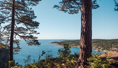
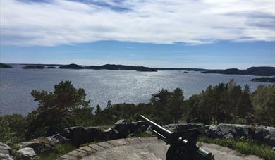
Fantastic viewpoints
When you walk from Åstadheia on the trail, you will have a fantastic view of Åbyfjorden and Rognsfjorden. Another viewpoint not to be missed is Vardås, which offers a spectacular view of the Bamble coastline.
Resting areas
From Åstadheia, near Stangodden, you continue on the trail to the right at a T-junction. However, it is worth taking a detour to the left towards the headland. Here, you will come across a boat harbor and a small recreational area with a nice view of the fjord. To the north, you will also find the idyllic and sheltered Elvikstranda, which provides bathing opportunities even for the youngest. The coastal trail passes by the sheltered lagoon of Lønnungen and the beautiful sandy beach of Prisgrunn. Ivarsand has now become one of the most visited recreational areas along the coast, with barbecue areas and toilets. A detour from the trail leads to the recreational area of Daumannsbukta (indicated by signs), a nice resting and bathing spot that is usually well protected from the wind. If you make the journey all the way up to Vardås, it is recommended to have a picnic there while enjoying the absolutely fantastic view. When you arrive at Trosby, you can sit down and relax or visit a café.
Swimming spots along the hike
Elvikstranda
Prisgrunn
Daumannsbukta
Ivarsand
Brevikstrand
Rakkestad
The Gem of Bamble's Coastline
From Ivarsand, you walk on the trail through Skarsvika to Brevikstrand. On the headland west of Skarsvika, there are good fishing opportunities and a nice place to take a break. Along the trail near Rakkestadstranda, there is a lean-to shelter where you can rest if the weather is bad. Rakkestadstranda is a recreational area with a beautiful, shallow sandy beach. This is one of the hidden gems of Bamble's coastline that you definitely shouldn't miss.
Shorter hikes
If you don't want to walk the entire stretch of this part of the coastal trail, the following shorter hikes are recommended:
Åby - Brevikstrand
Start your hike at Åby and follow the trail to Stangodden, Prisgrunn, Ivarsand, and Brevikstrand. Then, follow Valleveien back to Åby. Please note that Valleveien can be quite busy with traffic during the summer.
Trosby - Rakkestadstranda
Start your hike at the Trosby parking area. Walk eastward along Valleveien and turn right at the entrance to Rakkestad residential area. Please be aware that Valleveien can be heavily trafficked during the summer. When you reach Rakkestad residential area, follow the gravel road southward to Rakkestadstranda. Follow the coastal trail to Valås and then back to Trosby. This hike can be combined with a trip to the island Kjønnøya and Hafsund.
Parking
At Åby, there is a designated parking area. Follow Valleveien for about 1 km after the junction at Åby and turn left at the parking sign for the coastal trail. The parking area is located approximately 60-70 m from Valleveien.
Along the trail, there is a large public parking lot at Ivarsand. From there, it is a short distance to the beach. The area is wheelchair accessible.
Just before the intersection towards Stangodden, there is a parking area on the east side of the road.
Across the road from the store in Trosby, there is a large parking lot that you can use. You will also see signs for the coastal trail.
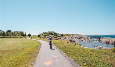
The trails are equipped with bridges, stairs, boardwalks, ropes, etc., and are marked with blue markings by Bamble Turlag/DNT Telemark.
Be a sustainable hiker
When exploring nature, it's essential to practice responsible behavior to preserve and respect the natural environment. This includes staying on the marked trails to avoid damaging ecosystems, taking your litter with you, and respecting local rules and restrictions. Make sure to avoid disturbing wildlife and be mindful of any special considerations related to protected areas. By acting responsibly during your outdoor activities, you contribute to maintaining the beauty and sustainability of nature, ensuring future generations to be able to enjoy it as well.
The landscape with the escarpments, "flauane" in Norwegian, is characteristic of the…
The Olav church ruin (Skeidi church) are the ruins of a stone church built before 1150 in…
Great hiking area near Rognstranda in Bamble. Beautiful forests and flora.
Bamble is dominated by two types of landscape with completely different geological…
At Rugtvedt in Bamble, a new exciting locality has emerged, a sandy beach that was…
The rocks in Steinvika were created in the earth's antiquity, for approx. 461-451 million…
Langesund customs warehouse as it stands today was erected in 1869.
Bamble's Landscape - Exciting Geology Through Millions of Years
Tollpakkboden is a log-built warehouse, the main part of which dates from the early 1700s.
The old guardhouse is now a customs museum, with artefacts found there from long ago.
The history of Langøytangen lighthouse station dates back to 1828.
As the first geopark in Scandinavia, Gea Norvegica became member of the Global Geoparks…
The Gea Norvegica Geopark visitor center is located at the porcelain factory in Porsgrunn…
 The Coastal Path - Bamble, BambleThe Bamble coastal path starts at the library in Stathelle and finishes at Fossing in Krageø, covering a stretch of approx, 62 km.
 Coastal path: Langesund - Rognstranda, BambleThis part of the trail is generally easy and straightforward to go, but can be hilly some places. Langesund is well worth a visit before continuing the trail.
 Hiking along the Coastal path : Rognstranda - Åby, BambleAt Rognstranda there is a campsite with a great sandy beach and barbecue area.
 Coastal path: Stathelle - Langesund, BambleThe trail starts at the bottom of the stairs from the Breviks bridge on the Stathelle side.
 Coastal path in Bamble :Trosby - Valle, BambleThis part of the coastal path is easy to walk, with no major elevation differences. Here are some of the pearls along the path.
 Hiking along the coastal path: Valle - Fossing, Bamble
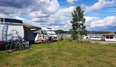 Sjøterrasssen motor home camp, BambleBeautifully located by the Trosbyfjord in Bamble. Short way to coastal path and cycle route no.1. Bathing place, restaurant and many activities all year round.
Ratings & Reviews
Powered By
![]()


© Visit Telemark 2026. Copyright
