Coastal path in Bamble :Trosby - Valle
Type:Coastal trails
3960, Stathelle


To build your own Itinerary, click  to add an item to your Itinerary basket.
Already saved an Itinerary?


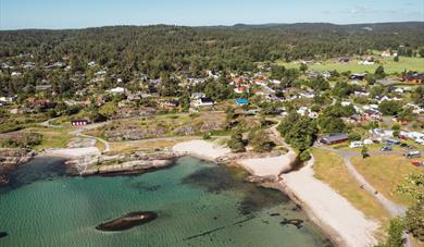
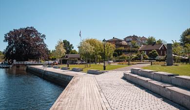
There is a shop at Trosby and here the road goes out to Kjønnøya. It is recommended to take a detour out there. Besides great scenery, with cozy roads and houses, there is also a nice outdoor area here (signposted) with good opportunities for fishing.
The trail starts on the west side of Kjønnøyaveien, continues through a campsite and out to the water's edge at a small marina. Furthermore, there is the nice Buvollen outdoor area, with great rock mountains and swimming opportunities. To the west you come to the idyllic Stranda farm, where the trail again goes completely to the water's edge overlooking the beautiful Trosby Fjord. It's a buzzing life in the summer.
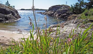
From Stranda Farm you follow the farm road and turn onto a forest path. After a short distance along Valleveien, you arrive at the idyllic Finmarkstrand. Here there are tables and benches for paddling and a nice sandy beach for swimming.
A little further along the Valleveien road you come to Sekkekilen, which was formerly used as a harbor for shipping. Here is the old powder cellar from the Napoleonic period and there is a model of an optical telegraph, which was used for signaling along the coast. There are good information boards about the central role of the Sekkekilen in the Napoleonic era.
From Sekkekilen you swing through a campsite and come to the Sjøterrassen restaurant, which is open for summer dining.
The coastal path goes around the Redlands, with cozy places for paddling along the seafront. After the round on Rødlandet, you almost return to Sekkekilen before the trail goes west to Trolldalen In Trolldalen the trail goes through a cozy cabin area before following the water's edge.
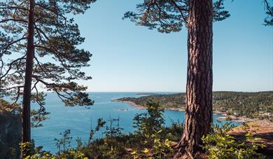
A little within the coastal path lies Trolldalen coastal fort. This was built during World War II and has many trenches and bunkers, as well as a restored cannon. From the fort there are great views of the Bamble Coast.
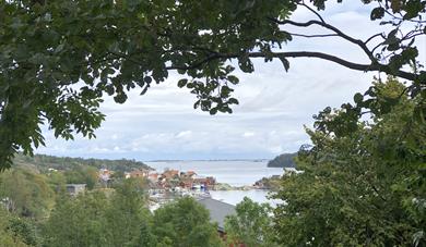
The trail runs along the water's edge almost all the way to Breisand and the stretch is a gem on the coastal path. Here you can study the mysteries of geology and enjoy a magnificent view of Stråholmen.
Breisand is an idyllic location along the fjord, with a mix of residential houses and leisure buildings. At the small beach at the far end it is nice to break. Valle has a shop, and in the summer months there is also ice cream and restaurant in a charming and busy guest harbor.
If you do not want to go all the way together, the following alternatives can be tried:
1. Start at Trosby and make your way out to Kjønnøya. Here you can make a small tour and perhaps visit the leisure area. Then follow the path west to Buvollen and Stranda farm. Return to Trosby on Valleveien. Please note that Valleveien is very busy in the summer. Be careful.
2. Start at Sjøterrassen and walk around Rødlandet. Continue to Trolldalen with a visit to the coastal fort, and return along Valleveien and the footpath at Sekkekilen.
3. Start at Valle and walk the coastal path to Trolldalen. Go to the coastal fort and follow the trail from there directly back to Breisand. This trail is unmarked and can be difficult to find, but is otherwise nice to walk. Follow the coastal path from Breisand back to Valle.
Parking:
Across the road from the shop at Trosby there is private parking for users of the coastal path. Then you can easily see the marks of the coastal path.
Directly within the Buvollen recreation area is a parking lot, several of which are public places. There is exit from Valleveien.
At Sjøterrassen there is parking for visitors.
At Valle there are many parking spaces, but be aware that many are private.
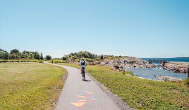
Length: Approx. 9.9 km
Duration: 3 hours +
Rating: Medium +
Suitable: Adult, child
Be a sustainable hiker
When exploring nature, it's essential to practice responsible behavior to preserve and respect the natural environment. This includes staying on the marked trails to avoid damaging ecosystems, taking your litter with you, and respecting local rules and restrictions. Make sure to avoid disturbing wildlife and be mindful of any special considerations related to protected areas. By acting responsibly during your outdoor activities, you contribute to maintaining the beauty and sustainability of nature, ensuring future generations to be able to enjoy it as well.
The landscape with the escarpments, "flauane" in Norwegian, is characteristic of the…
The Olav church ruin (Skeidi church) are the ruins of a stone church built before 1150 in…
Great hiking area near Rognstranda in Bamble. Beautiful forests and flora.
Bamble is dominated by two types of landscape with completely different geological…
The rocks in Steinvika were created in the earth's antiquity, for approx. 461-451 million…
The history of Langøytangen lighthouse station dates back to 1828.
Langesund customs warehouse as it stands today was erected in 1869.
Tollpakkboden is a log-built warehouse, the main part of which dates from the early 1700s.
The old guardhouse is now a customs museum, with artefacts found there from long ago.
Bamble's Landscape - Exciting Geology Through Millions of Years
At Rugtvedt in Bamble, a new exciting locality has emerged, a sandy beach that was…
As the first geopark in Scandinavia, Gea Norvegica became member of the Global Geoparks…
The Gea Norvegica Geopark visitor center is located at the porcelain factory in Porsgrunn…
 The Coastal Path - Bamble, BambleThe Bamble coastal path starts at the library in Stathelle and finishes at Fossing in Krageø, covering a stretch of approx, 62 km.
 Coastal path: Langesund - Rognstranda, BambleThis part of the trail is generally easy and straightforward to go, but can be hilly some places. Langesund is well worth a visit before continuing the trail.
 HIking along the coastal path in Bamble: Åby - Trosby, BambleThis part of the coastal path is generally easy and straightforward to walk, but there is a relatively steep hill up from Åby to Åstadheia.
 Hiking along the Coastal path : Rognstranda - Åby, BambleAt Rognstranda there is a campsite with a great sandy beach and barbecue area.
 Coastal path: Stathelle - Langesund, BambleThe trail starts at the bottom of the stairs from the Breviks bridge on the Stathelle side.
 Hiking along the coastal path: Valle - Fossing, Bamble
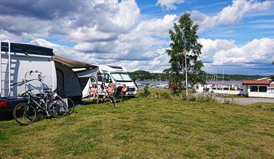 Sjøterrasssen motor home camp, BambleBeautifully located by the Trosbyfjord in Bamble. Short way to coastal path and cycle route no.1. Bathing place, restaurant and many activities all year round.
Ratings & Reviews
Powered By
![]()


© Visit Telemark 2026. Copyright
