The island Gumøy
Type:Island
Torvgata 1, 3770, Kragerø


To build your own Itinerary, click  to add an item to your Itinerary basket.
Already saved an Itinerary?


Gumøy is the third largest island in the Kragerø archipelago. This beautiful island is well hidden on the inner side of Jomfruland, and it takes about 20 min by ferry from central Kragerø to Eastern Gumøy (Ferry dock: Tangane). At Gumøy we find a wide variety of terrain, and thanks to the wild sheep in the area, the island is both bright and open.
Hiking
The entire island boasts of well executed hiking trails that makes their way through the magnificent landscape. The ferry port Tangane is a great place to start your hike. Here you will find a large map of the island with all the names of different areas of interest and the many sights the island has to offer. From here on out the island is easy to navigate, and within the summer season kicks in there will be as many as 50 signs all around the island, guiding you on your hike, from start to end.
The island is easy to navigate, but should you still wish to purchase a map, you can do so for the price of NOK100. The map can be bought at the viewpoint Signalen, or at the farms Ballestad an Isnes on the island. If you wish to pre-purchase the map you may do so by contacting Gumøy Velforening. In addition you will find maps of the island online at Norgeskart and MTBmap.
The archipelagos two most beautiful viewpoints.
At the islands highest point, Vestre Gumøyknuten, there is a 360 degrees view. At this point, known as Signalen, you will find one of the Kragerø-archipelagos two most beautiful viewpoints, 113 meters above sea level. Signalen is located at the west side of the island, towards Kragerø. There you´ll find a binocular viewer, which you can use for free!
The second half of the two most beautiful viewpoints in the Kragerø-archipelago you will find at Østre Gumøyknute, towering 107 meters above sea level. Here you will find Kragerøs best kept burial mound, probably dating all the way back to the Bronze Age. From Østre Gumøyknute you can follow the path down to Skutevika, which is a well-known and popular marina for boat tourists. Or the other way around. The roads and trails on the island are also great for cycling. By foot the hike takes about half an hour from Skutevika to the top. Remember to bring your binoculars.
The culture-trail
A great way to get better acquainted with Gumøy, is by hiking the 3km/2miles long culture-trail. All the way along the trail, you will find information boards that educates you on the area surrounding you and old local place names, history, fauna and geology. Read more about the culture-trail here!
Transportation.
Both the ferry, expressboat and taxi-boats take you from Kragerø to Gumøy.
The ferry departs from Kragerø to the ferry port on Tangange. The ferrytrip to Gumøy is part of the route Kragerø-Gumøy-Jomfruland, the trip here takes about 20 minutes minutes by ferry, and it is important to remember to tell the ferry crew that you are going to Gumøy not Jomfruland when you are purchasing your ticket on board, and by all means remember to disembark at Gumøy! Otherwise you`ll end up at Jomfruland.
The taxi-boats takes you wherever you want as long as there is a docking possibility there. Click here to see more information about the taxi-boats, and click here for timetables from Kragerø- Gumøy.
Skåtøy is the largest of Kragerø’s islands and has a flourishing Cultural life year-round…
The Skåtøy Church, also known as the Cathedral of the Skerries, was built in 1862. It is…
This idyllic forest lake at Jomfruland is where Theodor Kittelsen got inspiration for his…
Nice and atmospheric art sales exhibitions of different kinds in the school room, Bua and…
The two lighthouses located in the middle of Jomfruland are well-known landmarks. The…
'Pestas house' is located on the beautiful island of Skåtøy, only 10 minutes by ferry…
Jomfruland National Park was established on 16 December 2016 and covers an area of 117…
The island of Jomfruland is located on the outskirts of Kragerø's spectacular archipelago.
Krikken Coastal Fort, a German construction from World War 2 is well worth visiting. The…
Kragerø church was consecrated in 1870 and is a Gothic Revival church designed by Georg…
Gea Norvegica Geo Park is Scandinavia's first UNESCO certified geopark.
The geopark is…
With's boder is the red building located next to Jernbanetorvet. It was built in the…
Kragerø is referred to as "The gem among coastal cities" of Edvard Munch, Norway's most…
Minneparken (The Memorial Park) is located right beside Kragerø Church. There you find a…
Welcome Lars Lerins gallery in Kragerø!
In a beautifully restored townhouse in the heart…
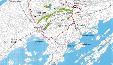 Gumøy Culture Trail, Kragerøia a heritage trail at Gumøy, is 2 miles long and starts at "Kvernmyra". The Kulturstien follows around the golf course, here you will find old ice dams, dolomite mines, garden soil, pasture landscape, ancient thoroughfares...
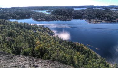 Signalen at Gumøy, KragerøVestre Gumøyknute/Signalen has the archipelago's second highest viewing point and offers a great hiking trip. “Signalen” towers 113metres over the ocean and offers a spectacular panoramic view of the archipelago.
Ratings & Reviews
Powered By
![]()


© Visit Telemark 2026. Copyright
