Stråholmen
Type:Island
3783, Kragerø Skjærgård


To build your own Itinerary, click  to add an item to your Itinerary basket.
Already saved an Itinerary?


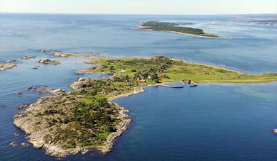
Stråholmen is about 1.5 km long and 1 km wide at the widest, and lays approximately 2 km north of the island Jomfruland. Stråholmen faces the Skagerrak seas to the east and provides shelter for the inner coast line. The name is Norwegian and literally translates to "The Islet of Straws".
History and settlement
At the center of the island lays a small settlement which today consists of cottages and leisure homes, populated mainly through the summer. The settlement on Stråholmen was originally created by the sailing ship piloting industry of the southern Telemark area, as the location is great for spotting ships arriving from the sea. By the late 1900s the settlement has lost its economical function as except for some sparse agricultural activity. The remainders of the settlement is considered an important part of the cultural inheritance of the shipping industry era of the southern Telemark district.
Facilities and nature
On the north side lies a sheltered dock and beach, frequently utilized as a recreation area for the local population and tourists. The dock is accessible by water taxi from nearby Kragerø, Valle (in Bamble) or Langesund, or by private vessel. The central settlement is reachable from the dock by a dirt path.
Stråholmen features several plants and tree types which are quite uncommon in the area, which were probably imported through seeds in ballast dirt during the shipping era. The island is great for hiking and the surrounding shores are considered good for sports fishing.
The bird life is rich, especially during the migration seasons. Ducks, geese and wading birds are especially abundant.
Stråholmen is a part of the Jomfruland National Park!
This idyllic forest lake at Jomfruland is where Theodor Kittelsen got inspiration for his…
Nice and atmospheric art sales exhibitions of different kinds in the school room, Bua and…
The two lighthouses located in the middle of Jomfruland are well-known landmarks. The…
Jomfruland National Park was established on 16 December 2016 and covers an area of 117…
The island of Jomfruland is located on the outskirts of Kragerø's spectacular archipelago.
Skåtøy is the largest of Kragerø’s islands and has a flourishing Cultural life year-round…
The Skåtøy Church, also known as the Cathedral of the Skerries, was built in 1862. It is…
Krikken Coastal Fort, a German construction from World War 2 is well worth visiting. The…
'Pestas house' is located on the beautiful island of Skåtøy, only 10 minutes by ferry…
Strømtangen fyr is one of three lighthouses in Kragerø and lies between Rapen and…
Kragerø church was consecrated in 1870 and is a Gothic Revival church designed by Georg…
Veten is Øyas magnificent viewpoint. From here you have the opportunity to experience…
Kragerø is referred to as "The gem among coastal cities" of Edvard Munch, Norway's most…
Gea Norvegica Geo Park is Scandinavia's first UNESCO certified geopark.
The geopark is…
With's boder is the red building located next to Jernbanetorvet. It was built in the…
 Jomfruland National Park, KragerøJomfruland National Park was established on 16 December 2016 and covers an area of 117 km2(45 sq mi), including the islands of Jomfruland and Stråholmen. About 98% in the park area is sea.
Ratings & Reviews
Powered By
![]()


© Visit Telemark 2026. Copyright
